


F68 - Anadarko Muni
Located in Anadarko, United States
ICAO - F68, IATA -
Data provided by AirmateGeneral information
Coordinates: N35°3'8" W98°15'51"
Elevation is 1291 feet MSL.
Magnetic variation is 07° East View others Airports in Oklahoma
Operational data
Special qualification required
Current time UTC:
Current local time:
Weather at : KCHK - Chickasha Muni ( 27 km )
METAR: KCHK 091435Z AUTO 03014KT 10SM BKN095 20/08 A2987 RMK AO2 T02030077
Communications frequencies: [VIEW]
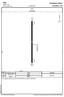
Runways:
| RWY identifier | QFU | Length (ft) | Width (ft) | Surface | LDA (ft) |
| 17 | 180° | 3100 | 50 | ASPH | |
| 35 | 0° | 3100 | 50 | ASPH |
Airport contact information
Address: Anadarko United States