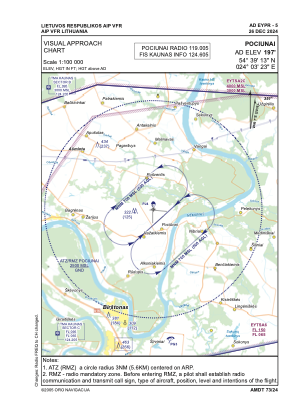
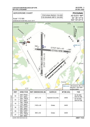


EYPR - Pociunai
Located in Prienai, Lithuania
ICAO - EYPR, IATA -
Data provided by AirmateGeneral information
Coordinates: N54°39'13" E24°3'23"
Elevation is 197 feet MSL.
Magnetic variation is 7° East View others Airports in Kaunas County
Operational data
Special qualification required
Current time UTC:
Current local time:
Weather at : EYKA - Kaunas/International ( 35 km )
METAR: EYKA 180020Z AUTO VRB01KT 9999 NCD 11/09 Q1018
TAF: TAF EYKA 172307Z 1800/1824 VRB03KT 9000 NSC TEMPO 1800/1803 1500 MIFG BR TEMPO 1806/1810 SCT050TCU TEMPO 1810/1818 VRB13G23KT 5000 SHRA BKN030CB PROB40 TEMPO 1811/1818 TS TEMPO 1821/1824 1500 MIFG BR
Communications frequencies: [VIEW]
Runways:
| RWY identifier | QFU | Length (ft) | Width (ft) | Surface | LDA (ft) |
| 04 | 48° | 2188 | 59 | CONC+ASPH | |
| 22 | 228° | 2188 | 59 | CONC+ASPH | |
| 18 | 185° | 3609 | 131 | GRASS | |
| 36 | 5° | 3609 | 131 | GRASS | |
| 09 | 95° | 2953 | 131 | GRASS | |
| 27 | 275° | 2953 | 131 | GRASS |
Airport contact information
Address: Prienai Lithuania
Other aviation service providers
Aviation club (not for profit)

Kauno Apskrities Aviacijos Sporto Klubas
Kauno Apskrities Aviacijos Sporto Klubas
vytas@pociunai.lt+37068536251
+37068536251
+37068536251