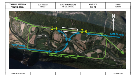
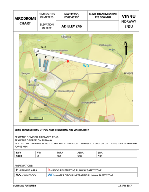


ENSU - Vinnu
Located in Sunndalsoera, Norway
ICAO - ENSU, IATA -
Data provided by AirmateGeneral information
Coordinates: N62°39'25" E8°40'53"
Elevation is 246 feet MSL.
Magnetic variation is 3° East View others Airports in Møre og Romsdal
Operational data
Special qualification required
Current time UTC:
Current local time:
Weather at : ENKB - Kvernberget ( 67 km )
METAR: ENKB 161650Z 26008KT 230V290 CAVOK 20/07 Q1018 RMK WIND 745FT 31007KT
TAF: TAF ENKB 161400Z 1615/1622 VRB05KT CAVOK
Communications frequencies: [VIEW]
Runways:
| RWY identifier | QFU | Length (ft) | Width (ft) | Surface | LDA (ft) |
| 10 | 0° | 1936 | 98 | Grass | |
| 28 | 0° | 1936 | 98 | Grass |
Airport contact information
Address: Sunndalsoera Norway