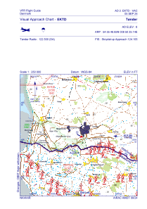
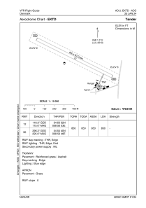


EKTD - Toender
Located in Toender, Denmark
ICAO - EKTD, IATA -
Data provided by AirmateGeneral information
Coordinates: N54°55'47" E8°50'25"
Elevation is 6 feet MSL.
Magnetic variation is +1.3° East View others Airports in South Denmark
Operational data
Special qualification required
Current time UTC:
Current local time:
Weather at : EDXW - Sylt ( 32 km )
METAR: EDXW 140020Z AUTO 10012KT 9999 // NCD 12/09 Q1012
TAF: TAF EDXW 131700Z 1318/1321 10015KT CAVOK
Communications frequencies: [VIEW]
Runways:
| RWY identifier | QFU | Length (ft) | Width (ft) | Surface | LDA (ft) |
| 12 | 0° | 2789 | 98 | UNK | |
| 30 | 0° | 2789 | 98 | UNK |
Airport contact information
Address: Toender Denmark
