


EGWU - Northolt
Located in Uxbride, United Kingdom
ICAO - EGWU, IATA - NHT
Data provided by AirmateGeneral information
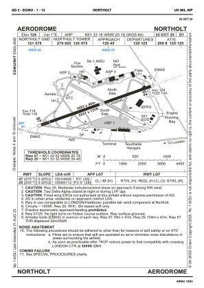
Coordinates: N51°33'10" W0°25'11"
Elevation is 126 feet MSL.
Magnetic variation is 0° East View others Airports in England
Operational data
Special qualification required
Current time UTC:
Current local time:
Weather
METAR: EGWU 221120Z 26013KT 9999 BKN011 BKN024 14/13 Q1006 TEMPO 4000 RADZ RMK GRN TEMPO GRN
TAF: TAF EGWU 221043Z 2212/2306 26012KT 9999 BKN018 TEMPO 2212/2223 5000 RA BKN012 PROB30 TEMPO 2212/2220 3000 +SHRA BKN010TCU
Communications frequencies: [VIEW]
Runways:
| RWY identifier | QFU | Length (ft) | Width (ft) | Surface | LDA (ft) |
| 07 | 70° | 5525 | 133 | ASPH | 4925 |
| 25 | 250° | 5525 | 133 | ASPH | 5112 |
Airport contact information
Address: Uxbride United Kingdom
