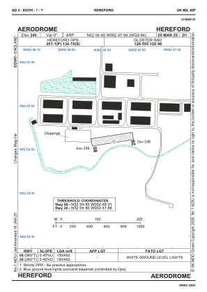


EGVH - Hereford
Located in Hereford, United Kingdom
ICAO - , IATA -
Data provided by AirmateGeneral information
Coordinates: N52°4'51" W2°47'56"
Elevation is 240 feet MSL.
Magnetic variation is -1° East View others Airports in England
Operational data
Special qualification required
Current time UTC:
Current local time:
Weather at : EGBJ - Gloucestershire ( 48 km )
METAR: EGBJ 221220Z 23005KT 200V270 6500 RA BKN010 OVC017 15/14 Q1007
TAF: TAF EGBJ 221102Z 2212/2219 24008KT 9999 OVC010 TEMPO 2212/2219 6000 RA BKN006 PROB30 TEMPO 2212/2216 3000 +RA BECMG 2216/2219 SCT010 BKN020
Communications frequencies: [VIEW]
Runways:
| RWY identifier | QFU | Length (ft) | Width (ft) | Surface | LDA (ft) |
| 08 | 0° | 492 | 68 | UNK | |
| 26 | 0° | 492 | 68 | UNK |
Airport contact information
Address: Hereford United Kingdom