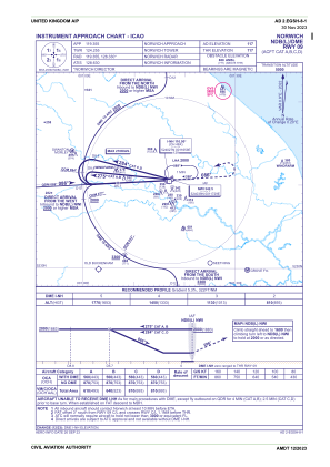
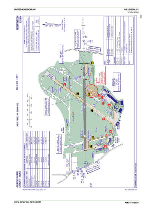


EGSH - Norwich
Located in Norwich, United Kingdom
ICAO - EGSH, IATA - NWI
Data provided by AirmateGeneral information
Coordinates: N52°40'33" E1°16'58"
Elevation is 117 feet MSL.
View others Airports in England
Operational data
Special qualification required
Current time UTC:
Current local time:
Weather
METAR: EGSH 120320Z AUTO 06004KT 1600 BR NCD 10/10 Q1017
TAF: TAF EGSH 120153Z 1203/1212 09007KT 2500 BR FEW040 TEMPO 1203/1206 0200 FG BKN000 PROB30 TEMPO 1203/1206 9999 NSW BECMG 1206/1209 9999 NSW
Communications frequencies: [VIEW]
Runways:
| RWY identifier | QFU | Length (ft) | Width (ft) | Surface | LDA (ft) |
| 09 | 89° | 6043 | 148 | ASP | |
| 27 | 269° | 6043 | 148 | ASP |
Airport contact information
Address: Norwich United Kingdom
