


EGOV - Valley
Located in Rhosneigr, United Kingdom
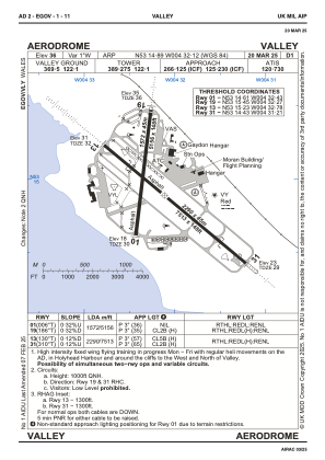
ICAO - EGOV, IATA - VLY
Data provided by AirmateGeneral information
Coordinates: N53°14'53" W4°32'7"
Elevation is 36 feet MSL.
Magnetic variation is -2° East View others Airports in Wales
Operational data
Special qualification required
Current time UTC:
Current local time:
Weather
METAR: EGOV 142150Z AUTO 10009KT 9999 BKN058/// BKN075/// 15/10 Q1000
TAF: TAF EGOV 141335Z 1415/1419 VRB03KT 9999 FEW028 SCT045
Communications frequencies: [VIEW]
Runways:
| RWY identifier | QFU | Length (ft) | Width (ft) | Surface | LDA (ft) |
| 01 | 6° | 5157 | 148 | ASPH | 5157 |
| 19 | 186° | 5157 | 148 | ASPH | 5157 |
| 13 | 130° | 7513 | 148 | ASPH | 7513 |
| 31 | 310° | 7513 | 148 | ASPH | 7513 |
Airport contact information
Address: Rhosneigr United Kingdom