


EGOQ - Mona
Located in Llangefni, United Kingdom
ICAO - EGOQ, IATA -
Data provided by AirmateGeneral information
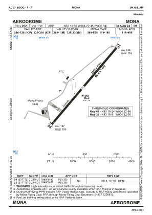
Coordinates: N53°15'33" W4°22'26"
Elevation is 201 feet MSL.
Magnetic variation is -2° East View others Airports in Wales
Operational data
Special qualification required
Current time UTC:
Current local time:
Weather at : EGOV - Valley ( 11 km )
METAR: EGOV 140020Z AUTO 14007KT 9999 -RA FEW032/// OVC082/// 13/13 Q0998
TAF: TAF EGOV 131334Z 1315/1319 13017KT 9999 -RA FEW018 BKN035 TEMPO 1315/1319 7000 RA BKN018 PROB30 TEMPO 1316/1319 BKN014
Communications frequencies: [VIEW]
Runways:
| RWY identifier | QFU | Length (ft) | Width (ft) | Surface | LDA (ft) |
| 04 | 37° | 5404 | 148 | ASPH | 5180 |
| 22 | 217° | 5404 | 148 | ASPH | 5404 |
Airport contact information
Address: Llangefni United Kingdom
Other aviation service providers
Flight schools

Mona Aviation Limited T/A Mona Flying Club
Mona Aviation Limited T/A Mona Flying Club
alex@cheshireproperties.co.uk+44 01407720581