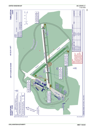


EGHO - Thruxton
Located in Andover, United Kingdom
ICAO - EGHO, IATA -
Data provided by AirmateGeneral information
Coordinates: N51°12'38" W1°36'0"
Elevation is 319 feet MSL.
View others Airports in England
Operational data
Special qualification required
Current time UTC:
Current local time:
Weather at : EGVP - Middle Wallop ( 7 km )
METAR: EGVP 112120Z 06007KT CAVOK 17/12 Q1017 NOSIG RMK BLU BLU
TAF: TAF EGVP 111933Z 1121/1124 10008KT CAVOK BECMG 1121/1123 7000 HZ
Communications frequencies: [VIEW]
Runways:
| RWY identifier | QFU | Length (ft) | Width (ft) | Surface | LDA (ft) |
| 07 | 67° | 3179 | 75 | Asphalt | |
| 25 | 247° | 3179 | 75 | Asphalt | |
| 12 | 123° | 2484 | 102 | Grass | |
| 30 | 303° | 2484 | 102 | Grass |
Airport contact information
Address: Andover United Kingdom