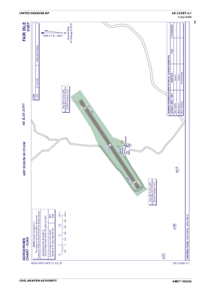


EGEF - Fair Isle
Located in Fair Isle, United Kingdom
ICAO - EGEF, IATA - FIE
Data provided by AirmateGeneral information
Coordinates: N59°32'5" W1°37'43"
Elevation is 237 feet MSL.
View others Airports in Scotland
Operational data
Special qualification required
Current time UTC:
Current local time:
Weather at : EGPB - Sumburgh ( 43 km )
METAR: EGPB 221020Z 09005KT 9999 FEW040 14/11 Q1013 TEMPO SHRA
TAF: TAF EGPB 220800Z 2209/2218 08007KT 9999 FEW020 TEMPO 2210/2215 6000 SHRA PROB30 TEMPO 2212/2215 3000 +SHRA
Communications frequencies: [VIEW]
Runways:
| RWY identifier | QFU | Length (ft) | Width (ft) | Surface | LDA (ft) |
| 06 | 57° | 1772 | 72 | Gravel | |
| 24 | 237° | 1772 | 72 | Gravel |
Airport contact information
Address: Fair Isle United Kingdom