


EGDI - Merryfield
Located in Ilminster, United Kingdom
ICAO - , IATA -
Data provided by AirmateGeneral information
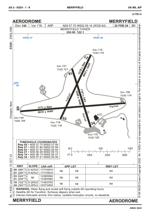
Coordinates: N50°57'45" W2°56'8"
Elevation is 144 feet MSL.
Magnetic variation is -1° East View others Airports in England
Operational data
Special qualification required
Current time UTC:
Current local time:
Weather at : EGDY - Yeovilton ( 21 km )
METAR: EGDY 220603Z 26004KT 4500 -RA SCT008 OVC070 13/12 Q1008 RMK GRN
TAF: TAF EGDY 220518Z 2206/2215 29010KT 5000 RA FEW006 SCT010 BECMG 2209/2211 30010G20KT 9999 SCT030 TEMPO 2209/2215 7000 -RA TEMPO 2209/2215 4000 SHRA SCT020TCU PROB30 TEMPO 2209/2215 2500 +TSRAGR SCT010 BKN018CB
Communications frequencies: [VIEW]
Runways:
| RWY identifier | QFU | Length (ft) | Width (ft) | Surface | LDA (ft) |
| 09 | 85° | 5810 | 164 | ASPH | 5810 |
| 27 | 265° | 5810 | 164 | ASPH | 5810 |
| 03 | 24° | 4062 | 164 | ASPH | 4062 |
| 21 | 204° | 4062 | 164 | ASPH | 4062 |
| 16 | 162° | 3809 | 164 | ASPH | 3753 |
| 34 | 342° | 3809 | 164 | ASPH | 3402 |
Airport contact information
Address: Ilminster United Kingdom