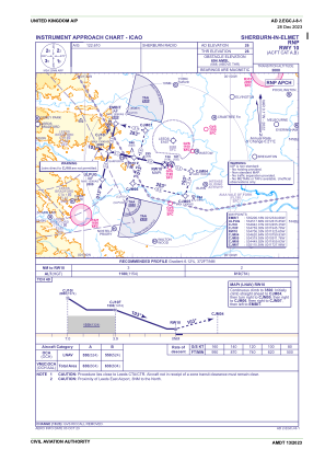
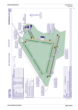


EGCJ - Sherburn-In-Elmet
Located in Selby, United Kingdom
ICAO - EGCJ, IATA -
Data provided by AirmateGeneral information
Coordinates: N53°47'3" W1°13'4"
Elevation is 26 feet MSL.
View others Airports in England
Operational data
Special qualification required
Current time UTC:
Current local time:
Weather at : EGNM - Leeds Bradford ( 30 km )
METAR: EGNM 220720Z 35010KT 6000 -RA SCT003 BKN006 12/11 Q1006
TAF: TAF AMD EGNM 220605Z 2206/2306 34010KT 0500 FG OVC001 BECMG 2206/2208 9999 NSW SCT010 BKN020 TEMPO 2206/2306 6000 RA -RADZ BKN010 PROB30 TEMPO 2206/2218 3000 +RA RADZ BKN007 BECMG 2214/2217 28010KT PROB30 TEMPO 2218/2306 3000 RADZ BKN006 BECMG 2219/2222 22010KT
Communications frequencies: [VIEW]
Runways:
| RWY identifier | QFU | Length (ft) | Width (ft) | Surface | LDA (ft) |
| 06 | 58° | 2530 | 69 | Grass | |
| 24 | 238° | 2530 | 69 | Grass | |
| 01 | 8° | 1906 | 69 | Grass | |
| 19 | 188° | 1906 | 69 | Grass | |
| 10G | 103° | 0 | 0 | UNK | |
| 28G | 283° | 0 | 0 | UNK | |
| 10 | 103° | 2717 | 59 | UNK | |
| 28 | 283° | 2717 | 59 | UNK |
Airport contact information
Address: Selby United Kingdom
Other aviation service providers
Flight schools

Advanced Flight Training Limited
Advanced Flight Training Limited
info@advancedflighttraining.co.uk+44 01977680998
