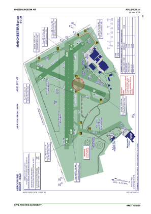


EGCB - Manchester/Barton
Located in Manchester, United Kingdom
ICAO - EGCB, IATA -
Data provided by AirmateGeneral information
Coordinates: N53°28'18" W2°23'23"
Elevation is 73 feet MSL.
View others Airports in England
Operational data
Special qualification required
Current time UTC:
Current local time:
Weather at : EGCC - Manchester ( 15 km )
TAF: TAF EGCC 151656Z 1518/1624 10005KT 9999 SCT035 PROB30 TEMPO 1604/1612 5000 -RADZ BR TEMPO 1612/1620 7000 SHRA BKN008 PROB30 TEMPO 1612/1620 4000 +SHRA BKN004 TEMPO 1620/1624 BKN004
Communications frequencies: [VIEW]
Runways:
| RWY identifier | QFU | Length (ft) | Width (ft) | Surface | LDA (ft) |
| 02 | 15° | 1699 | 105 | GRASS | |
| 20 | 195° | 1699 | 105 | GRASS | |
| 14 | 134° | 1306 | 105 | GRASS | |
| 32 | 314° | 1306 | 105 | GRASS | |
| 08R | 83° | 2054 | 105 | UNK | |
| 26L | 263° | 2054 | 105 | UNK | |
| 08L | 83° | 2103 | 98 | UNK | |
| 26R | 263° | 2103 | 98 | UNK |
Airport contact information
Address: Manchester United Kingdom
Other aviation service providers
Flight schools

Stuart Knox T/A High Peak Helicopters
Stuart Knox T/A High Peak Helicopters
stuart@highpeakhelicopters.com+44 01625529631
Upperstack Limited T/A Lac Flying School
Upperstack Limited T/A Lac Flying School
lacflyingschool@gmail.com+44 01617877326