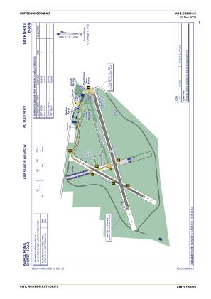


EGBM - Tatenhill
Located in Burton-On-Trent, United Kingdom
ICAO - EGBM, IATA -
Data provided by AirmateGeneral information
Coordinates: N52°48'51" W1°45'53"
Elevation is 439 feet MSL.
View others Airports in England
Operational data
Special qualification required
Current time UTC:
Current local time:
Weather at : EGNX - East Midlands ( 29 km )
METAR: EGNX 221220Z 27014KT 9000 -RA SCT008 BKN037 14/13 Q1004
TAF: TAF EGNX 221056Z 2212/2312 26013KT 9999 SCT006 BKN030 TEMPO 2212/2215 6000 RA BKN006 PROB30 TEMPO 2212/2215 3000 +RA BR TEMPO 2215/2303 8000 -RA BKN010 PROB40 TEMPO 2218/2303 4000 RA BKN008 PROB40 TEMPO 2222/2312 25018G28KT PROB30 TEMPO 2303/2308 BKN012
Communications frequencies: [VIEW]
Runways:
| RWY identifier | QFU | Length (ft) | Width (ft) | Surface | LDA (ft) |
| 08 | 74° | 3904 | 92 | Asphalt | |
| 26 | 254° | 3904 | 92 | Asphalt | |
| 04 | 0° | 1755 | 59 | UNK | |
| 22 | 0° | 1755 | 59 | UNK |
Airport contact information
Address: Burton-On-Trent United Kingdom
Other aviation service providers
Flight schools

Craig Padfield T/A Central Flight Training
Craig Padfield T/A Central Flight Training
info@centralflighttraining.com+44 07870578328