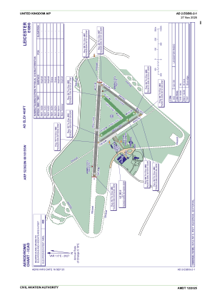


EGBG - Leicester
Located in Leicester, United Kingdom
ICAO - EGBG, IATA -
Data provided by AirmateGeneral information
Coordinates: N52°36'28" W1°1'55"
Elevation is 469 feet MSL.
View others Airports in England
Operational data
Special qualification required
Current time UTC:
Current local time:
Weather at : EGNX - East Midlands ( 32 km )
TAF: TAF EGNX 151703Z 1518/1618 11011KT 9999 FEW025 BECMG 1518/1521 05005KT PROB40 TEMPO 1518/1520 6000 SHRA BKN014 BECMG 1523/1602 6000 BKN005 TEMPO 1600/1606 3000 BR BKN003 BECMG 1606/1608 9999 SCT020 TEMPO 1608/1618 6000 SHRA RA PROB30 TEMPO 1608/1616 4000 +SHRA BKN014 BKN020CB
Communications frequencies: [VIEW]
Runways:
| RWY identifier | QFU | Length (ft) | Width (ft) | Surface | LDA (ft) |
| 16 | 150° | 1371 | 98 | GRS | |
| 34 | 330° | 1371 | 98 | GRS | |
| 06 | 49° | 1115 | 98 | GRS | |
| 24 | 229° | 1115 | 98 | GRS | |
| 15 | 149° | 1624 | 59 | ASP | |
| 33 | 329° | 1624 | 59 | ASP | |
| 04 | 40° | 1608 | 59 | ASP | |
| 22 | 220° | 1608 | 59 | ASP | |
| 10 | 96° | 3067 | 98 | ASP | |
| 28 | 276° | 3067 | 98 | ASP |
Airport contact information
Address: Leicester United Kingdom
Other aviation service providers
Flight schools

Leicestershire Aero Club Limited
Leicestershire Aero Club Limited
info@leicesterairport.com+44 01162592360