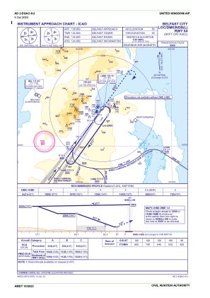
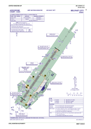


EGAC - Belfast/City
Located in Belfast, United Kingdom
ICAO - EGAC, IATA - BHD
Data provided by AirmateGeneral information
Coordinates: N54°37'5" W5°52'21"
Elevation is 15 feet MSL.
View others Airports in Northern Ireland
Operational data
Special qualification required
Current time UTC:
Current local time:
Weather
METAR: EGAC 132020Z AUTO 15009KT 120V190 4400 RA BKN005 OVC008 14/13 Q0998
TAF: TAF EGAC 131655Z 1318/1403 12010KT 9999 SCT020 TEMPO 1318/1324 6000 RA BKN012 PROB30 TEMPO 1318/1322 3000 RADZ BKN004 PROB30 TEMPO 1318/1319 13015G25KT PROB30 TEMPO 1322/1324 4000 RADZ BKN008
Communications frequencies: [VIEW]
Runways:
| RWY identifier | QFU | Length (ft) | Width (ft) | Surface | LDA (ft) |
| 04 | 35° | 6001 | 148 | ASP | |
| 22 | 215° | 6001 | 148 | ASP |
Airport contact information
Address: Belfast United Kingdom
