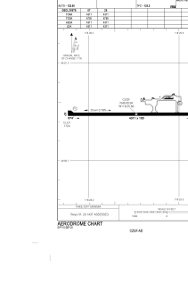


CZGF - Grand Forks
Located in , Canada
ICAO - CZGF, IATA - ZGF
Data provided by AirmateGeneral information
Coordinates: N49°0'56" W118°25'50"
Elevation is 1724 feet MSL.
Magnetic variation is 15.7978° East View others Airports in British Columbia
Operational data
Special qualification required
Current time UTC:
Current local time:
Weather at : CYCG - West Kootenay Regional ( 66 km )
METAR: CYCG 172100Z 29011G21KT 270V330 15SM BKN075 14/M02 A2987 RMK AC7 SLP121 DENSITY ALT 2000FT
TAF: TAF CYCG 171840Z 1719/1804 30010G20KT P6SM FEW040 BKN070 TEMPO 1719/1801 P6SM VCSH FM180100 34008KT P6SM SCT070 RMK NXT FCST BY 180100Z
Communications frequencies: [VIEW]
Runways:
| RWY identifier | QFU | Length (ft) | Width (ft) | Surface | LDA (ft) |
| 07 | 90° | 4311 | 100 | ASPH | 4311 |
| 25 | 270° | 4311 | 100 | ASPH | 4311 |
Airport contact information
Address: Canada