


CYXJ - Fort St. John
Located in Fort St. John, Canada
ICAO - CYXJ, IATA - YXJ
Data provided by AirmateGeneral information
Coordinates: N56°14'18" W120°44'25"
Elevation is 2280 feet MSL.
Magnetic variation is 16.9311° East View others Airports in British Columbia
Operational data
Special qualification required
Current time UTC:
Current local time:
Weather
METAR: CYXJ 172100Z 28012G18KT 260V360 60SM SCT071 SCT230 14/M04 A2979 RMK CU3CI1 SLP111 DENSITY ALT 2900FT
TAF: TAF CYXJ 171840Z 1719/1807 30012KT P6SM SCT040 BKN220 TEMPO 1719/1722 BKN040 BECMG 1800/1802 20006KT RMK NXT FCST BY 180100Z
Communications frequencies: [VIEW]
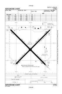
Runways:
| RWY identifier | QFU | Length (ft) | Width (ft) | Surface | LDA (ft) |
| 03 | 45° | 6698 | 148 | ASPH | 6698 |
| 21 | 225° | 6698 | 148 | ASPH | 6502 |
| 12 | 135° | 6909 | 150 | ASPH | 6909 |
| 30 | 315° | 6909 | 150 | ASPH | 6909 |
Airport contact information
Address: Fort St. John Canada