


CYXC - Canadian Rockies
Located in Cranbrook, Canada
ICAO - CYXC, IATA - YXC
Data provided by AirmateGeneral information
Coordinates: N49°36'44" W115°46'55"
Elevation is 3084 feet MSL.
Magnetic variation is 14.8839° East View others Airports in British Columbia
Operational data
Special qualification required
Current time UTC:
Current local time:
Weather
METAR: CYXC 172347Z 19007KT 20SM FEW005 FEW015 SCT045 BKN120 06/04 A2984 RMK SF1SF1SC2AS3 SLP126
TAF: TAF CYXC 171840Z 1719/1807 VRB03KT P6SM SCT020 BKN060 TEMPO 1719/1801 VRB15G25KT P6SM -SHRA VCTS BKN020 BKN050CB FM180100 27008KT P6SM SCT070 RMK NXT FCST BY 180100Z
Communications frequencies: [VIEW]
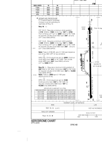
Runways:
| RWY identifier | QFU | Length (ft) | Width (ft) | Surface | LDA (ft) |
| 16 | 179° | 8000 | 150 | ASPH | 7220 |
| 34 | 359° | 8000 | 150 | ASPH | 8000 |
Airport contact information
Address: Cranbrook Canada