


CYSW - Elk Valley
Located in Sparwood, Canada
ICAO - CYSW, IATA -
Data provided by AirmateGeneral information
Coordinates: N49°50'6" W114°52'43"
Elevation is 3853 feet MSL.
Magnetic variation is 14.9667° East View others Airports in British Columbia
Operational data
Special qualification required
Current time UTC:
Current local time:
Weather at : CYXC - Canadian Rockies ( 69 km )
METAR: CYXC 172000Z 01014KT 15SM -SHRA SCT010 BKN022 OVC060 05/03 A2972 RMK SF4SC2SC2 VIS N 8 CVCTV CLD EMBD N PRESRR SLP080
Communications frequencies: [VIEW]
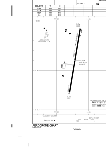
Runways:
| RWY identifier | QFU | Length (ft) | Width (ft) | Surface | LDA (ft) |
| 17 | 190° | 3963 | 75 | ASPH | 3963 |
| 35 | 10° | 3963 | 75 | ASPH | 3963 |
Airport contact information
Address: Sparwood Canada