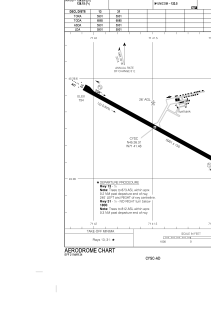


CYSC - Sherbrooke
Located in Sherbrooke, Canada
ICAO - CYSC, IATA - YSC
Data provided by AirmateGeneral information
Coordinates: N45°26'19" W71°41'29"
Elevation is 792 feet MSL.
Magnetic variation is -15.6633° East View others Airports in Quebec
Operational data
Special qualification required
Current time UTC:
Current local time:
Weather
METAR: CYSC 190100Z AUTO 10003KT 9SM FEW047 OVC066 15/13 A3002 RMK SLP171 DENSITY ALT 1000FT
TAF: TAF CYSC 182340Z 1900/1903 06005KT P6SM BKN040 OVC060 BECMG 1900/1902 VRB03KT RMK FCST BASED ON AUTO OBS. NXT FCST BY 191100Z
Communications frequencies: [VIEW]
Runways:
| RWY identifier | QFU | Length (ft) | Width (ft) | Surface | LDA (ft) |
| 13 | 119° | 5901 | 150 | ASPH | 5901 |
| 31 | 299° | 5901 | 150 | ASPH | 5901 |
Airport contact information
Address: Sherbrooke Canada
