


CYDP - Nain
Located in , Canada
ICAO - CYDP, IATA - YDP
Data provided by AirmateGeneral information
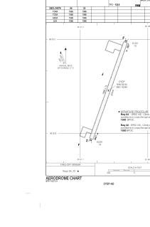
Coordinates: N56°33'2" W61°40'56"
Elevation is 21 feet MSL.
Magnetic variation is -21.6646° East View others Airports in Newfoundland and Labrador
Operational data
Special qualification required
Current time UTC:
Current local time:
Weather
METAR: CYDP 172300Z 08006KT 15SM FEW007 FEW013 BKN022 01/M01 A3040 RMK ST1SC2SC5 ST TR LAST STFD OBS/NXT 180800Z SLP298
TAF: TAF CYDP 171940Z 1720/1723 08010KT P6SM SCT009 OVC025 TEMPO 1720/1723 P6SM -RA SCT007 BKN009 OVC025 RMK NXT FCST BY 181000Z
Communications frequencies: [VIEW]
Runways:
| RWY identifier | QFU | Length (ft) | Width (ft) | Surface | LDA (ft) |
| 04 | 20° | 1986 | 75 | GRAVE | 1986 |
| 22 | 200° | 1986 | 75 | GRAVE | 1986 |
Airport contact information
Address: Canada