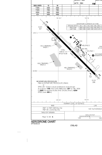


CYBL - Campbell River
Located in Campbell River, Canada
ICAO - CYBL, IATA - YBL
Data provided by AirmateGeneral information
Coordinates: N49°57'7" W125°16'23"
Elevation is 357 feet MSL.
Magnetic variation is 17.5278° East View others Airports in British Columbia
Operational data
Special qualification required
Current time UTC:
Current local time:
Weather
METAR: CYBL 172100Z 02011G18KT 340V050 30SM SCT050 BKN260 16/02 A3007 RMK CU3CI4 SLP187
TAF: TAF CYBL 171840Z 1719/1804 33012G22KT P6SM FEW050 BECMG 1719/1721 02010KT FM172100 02010KT P6SM SCT050 TEMPO 1721/1804 BKN050 BECMG 1801/1803 VRB03KT RMK NXT FCST BY 180100Z
Communications frequencies: [VIEW]
Runways:
| RWY identifier | QFU | Length (ft) | Width (ft) | Surface | LDA (ft) |
| 12 | 135° | 6499 | 150 | ASPH | 6499 |
| 30 | 315° | 6499 | 150 | ASPH | 6499 |
Airport contact information
Address: Campbell River Canada
