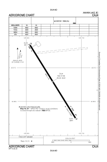


CAJ4 - Anahim Lake
Located in Anahim Lake, Canada
ICAO - CAJ4, IATA - YAA
Data provided by AirmateGeneral information
Coordinates: N52°27'5" W125°18'13"
Elevation is 3644 feet MSL.
Magnetic variation is 18.0614° East View others Airports in British Columbia
Operational data
Special qualification required
Current time UTC:
Current local time:
Weather at : - ( 0 km )
METAR: PKWA 172040Z AUTO 08014KT 10SM CLR 29/24 A2980 RMK AO2 T02870238 TSNO
Communications frequencies: [VIEW]
Runways:
| RWY identifier | QFU | Length (ft) | Width (ft) | Surface | LDA (ft) |
| 13 | 148° | 4642 | 75 | ASPH | 4642 |
| 31 | 328° | 4642 | 75 | ASPH | 4642 |
Airport contact information
Address: Anahim Lake Canada