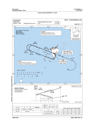
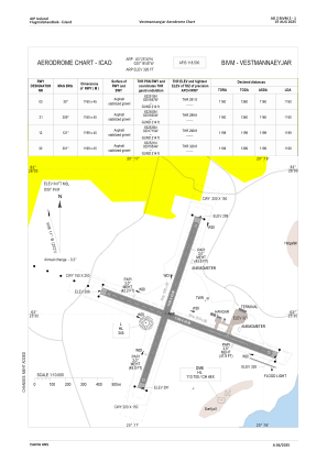


BIVM - Vestmannaeyjar
Located in Vestmannaeyjabaer, Iceland
ICAO - BIVM, IATA - VEY
Data provided by AirmateGeneral information
Coordinates: N63°25'30" W20°16'45"
Elevation is 326 feet MSL.
View others Airports in South
Operational data
Special qualification required
Current time UTC:
Current local time:
Weather
METAR: BIVM 111400Z 13011KT 9999 FEW070 09/07 Q1006
TAF: TAF BIVM 111305Z 1114/1120 10022KT 9999 -DZ OVC014 TEMPO 1114/1120 0400 -DZ FG VV001
Communications frequencies: [VIEW]
Runways:
| RWY identifier | QFU | Length (ft) | Width (ft) | Surface | LDA (ft) |
| 12 | 110° | 3934 | 148 | GRAVE | |
| 30 | 290° | 3934 | 148 | GRAVE | |
| 03 | 19° | 3806 | 148 | GRAVE | |
| 21 | 199° | 3806 | 148 | GRAVE |
Airport contact information
Address: Vestmannaeyjabaer Iceland