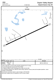


A34 - Dayton Valley Airpark
Located in Dayton/Carson City, United States
ICAO - A34, IATA -
Data provided by AirmateGeneral information
Coordinates: N39°14'18" W119°33'20"
Elevation is 4414 feet MSL.
Magnetic variation is 16° East View others Airports in Nevada
Operational data
Special qualification required
Current time UTC:
Current local time:
Weather at : KCXP - Carson City ( 16 km )
METAR: KCXP 090115Z AUTO 07013G20KT 10SM CLR 14/M10 A3008 RMK AO2
TAF: KCXP 082320Z 0900/0924 07011G22KT P6SM FEW200 FM090600 03005KT P6SM FEW200 FM091600 07014G26KT P6SM SCT050
Communications frequencies: [VIEW]
Runways:
| RWY identifier | QFU | Length (ft) | Width (ft) | Surface | LDA (ft) |
| 05 | 65° | 5343 | 75 | ASPH | |
| 23 | 245° | 5343 | 75 | ASPH |
Airport contact information
Address: Dayton/Carson City United States