


A09 - Eagle Airpark
Located in Bullhead City, United States
ICAO - A09, IATA -
Data provided by AirmateGeneral information
Coordinates: N34°53'17" W114°36'60"
Elevation is 485 feet MSL.
Magnetic variation is 13° East View others Airports in Arizona
Operational data
Special qualification required
Current time UTC:
Current local time:
Weather at : KEED - Needles ( 14 km )
METAR: KEED 172156Z AUTO 16014G23KT 10SM CLR 38/04 A2971 RMK AO2 SLP024 T03830044
TAF: KEED 171720Z 1718/1818 19008KT P6SM SKC FM171900 20010G18KT P6SM SKC FM180400 24010KT P6SM SKC FM181200 VRB05KT P6SM BKN250 FM181700 19008KT P6SM SCT250
Communications frequencies: [VIEW]
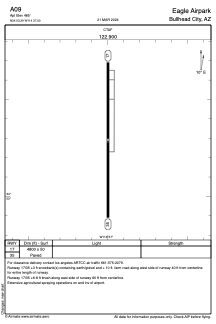
Runways:
| RWY identifier | QFU | Length (ft) | Width (ft) | Surface | LDA (ft) |
| 17 | 0° | 4800 | 50 | ASPH | |
| 35 | 0° | 4800 | 50 | ASPH |
Airport contact information
Address: Bullhead City United States