


9S7 - Winifred
Located in Winifred, United States
ICAO - 9S7, IATA -
Data provided by AirmateGeneral information
Coordinates: N47°33'19" W109°23'12"
Elevation is 3354 feet MSL.
Magnetic variation is 16° East View others Airports in Montana
Operational data
Special qualification required
Current time UTC:
Current local time:
Weather at : KLWT - Lewistown Muni ( 57 km )
METAR: KLWT 081354Z AUTO 30011G24KT 3SM RA BR BKN017 OVC023 01/01 A2983 RMK AO2 PK WND 30032/1258 UPE1258B13E29RAB1258E13B29 SLP123 P0018 T00060006
TAF: KLWT 081141Z 0812/0912 30016G25KT 6SM -SNRA SCT004 OVC015 TEMPO 0812/0816 2SM -SN BR OVC004 FM081600 31013G22KT 6SM -RA SCT006 OVC015 TEMPO 0816/0819 3SM -RASN OVC006 FM082000 33011G18KT 6SM -RA SCT008 BKN012 FM090400 31009KT P6SM SCT003 BKN012
Communications frequencies: [VIEW]
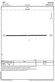
Runways:
| RWY identifier | QFU | Length (ft) | Width (ft) | Surface | LDA (ft) |
| 08 | 90° | 4400 | 150 | GRASS | |
| 26 | 270° | 4400 | 150 | GRASS |
Airport contact information
Address: Winifred United States