


9I3 - West Liberty
Situé à West Liberty, United States
ICAO - 9I3, IATA -
Données fournies par AirmateInformation générale
Coordonnées: N37°54'52" W83°15'7"
Élévation : 934 feet MSL.
Variation magnétique : -04° East Voir autres Aéroports à Kentucky
Données opérationnelles
Special qualification required
Heure actuelle UTC:
Heure actuelle locale:
Météo à : KJKL - Julian Carroll ( 36 km )
METAR: KJKL 190053Z AUTO 00000KT 10SM BKN095 21/17 A2989 RMK AO2 SLP111 T02060167
TAF: KJKL 182338Z 1900/1924 VRB03KT P6SM SCT100 FM190700 VRB03KT 5SM BR FEW150 FM190900 VRB03KT 2SM BR FEW035 FM191000 VRB03KT 1/4SM FG FEW035 FM191200 VRB03KT 4SM BR FEW035 FM191300 VRB03KT P6SM FEW200
Fréquences de communication: [VIEW]
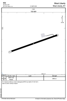
Pistes:
| Identifiant RWY | QFU | Longueur (ft) | Largeur (ft) | Surface | LDA (ft) |
| 07 | 71° | 2400 | 60 | ASPH | |
| 25 | 251° | 2400 | 60 | ASPH |
Coordonnées de l'aéroport
Adresse: West Liberty United States