


8S4 - Enterprise Muni
Located in Enterprise, United States
ICAO - 8S4, IATA -
Data provided by AirmateGeneral information
Coordinates: N45°25'29" W117°15'53"
Elevation is 3957 feet MSL.
Magnetic variation is 18° East View others Airports in Oregon
Operational data
Special qualification required
Current time UTC:
Current local time:
Weather at : KLGD - La Grande/Union County ( 60 km )
METAR: KLGD 081256Z AUTO 32010KT 10SM CLR 02/M01 A3026 RMK AO2 SLP259 T00171006 FZRANO
Communications frequencies: [VIEW]
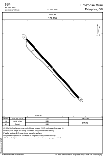
Runways:
| RWY identifier | QFU | Length (ft) | Width (ft) | Surface | LDA (ft) |
| 12 | 138° | 2850 | 50 | ASPH | |
| 30 | 318° | 2850 | 50 | ASPH |
Airport contact information
Address: Enterprise United States
