


89CA - Halter Ranch
Located in Paso Robles, United States
ICAO - 89CA, IATA -
Data provided by AirmateGeneral information
Coordinates: N35°38'40" W120°51'1"
Elevation is 1488 feet MSL.
Magnetic variation is 15° East View others Airports in California
Operational data
Special qualification required
Current time UTC:
Current local time:
Weather at : KPRB - Paso Robles Muni ( 20 km )
METAR: KPRB 180253Z AUTO 20014KT 10SM CLR 13/09 A2990 RMK AO2 SLP123 T01280094 53009
TAF: KPRB 172342Z 1800/1824 21015G22KT P6SM SKC FM180200 21010KT P6SM SKC FM180500 VRB03KT P6SM OVC007 FM181500 21006KT P6SM OVC012 FM181900 21013KT P6SM SKC FM182100 21018G25KT P6SM SKC
Communications frequencies: [VIEW]
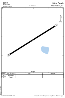
Runways:
| RWY identifier | QFU | Length (ft) | Width (ft) | Surface | LDA (ft) |
| 04 | 0° | 3353 | 25 | ASPH | |
| 22 | 0° | 3353 | 25 | ASPH |
Airport contact information
Address: Paso Robles United States