


83K - Harris
Located in Fort Ann, United States
ICAO - 83K, IATA -
Data provided by AirmateGeneral information
Coordinates: N43°24'35" W73°31'58"
Elevation is 261 feet MSL.
View others Airports in New York
Operational data
Special qualification required
Current time UTC:
Current local time:
Weather at : KGFL - Floyd Bennett Meml ( 10 km )
METAR: KGFL 081258Z AUTO 36003KT 3SM -RA BR BKN004 OVC029 10/10 A2962 RMK AO2 P0000 T01000100
TAF: KGFL 081124Z 0812/0912 VRB04KT 6SM -SHRA BR BKN060 TEMPO 0812/0813 2SM TSRA BR BKN025 OVC040CB FM081300 07005KT P6SM VCSH BKN015 FM081900 26012G21KT P6SM SCT060 FM090000 28008KT P6SM VCSH BKN040 FM090600 31006KT P6SM BKN020 FM090800 35005KT P6SM SCT012 OVC020
Communications frequencies: [VIEW]
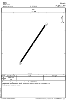
Runways:
| RWY identifier | QFU | Length (ft) | Width (ft) | Surface | LDA (ft) |
| 04 | 34° | 2200 | 50 | GRASS | |
| 22 | 214° | 2200 | 50 | GRASS |
Airport contact information
Address: Fort Ann United States