


6Y0 - Moorestown Airpark
Located in Moorestown, United States
ICAO - 6Y0, IATA -
Data provided by AirmateGeneral information
Coordinates: N44°27'47" W84°59'48"
Elevation is 1211 feet MSL.
Magnetic variation is -05° East View others Airports in Michigan
Operational data
Special qualification required
Current time UTC:
Current local time:
Weather at : KHTL - Roscommon County/Blodgett Meml ( 28 km )
METAR: KHTL 081153Z AUTO 28016G24KT 10SM OVC013 12/11 A2958 RMK AO2 PK WND 26026/1103 SLP017 60004 70010 T01220106 10133 20111 53016
Communications frequencies: [VIEW]
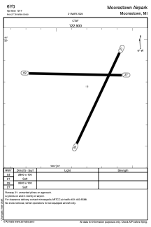
Runways:
| RWY identifier | QFU | Length (ft) | Width (ft) | Surface | LDA (ft) |
| 03 | 25° | 2800 | 100 | GRASS | |
| 21 | 205° | 2800 | 100 | GRASS | |
| 09 | 91° | 2600 | 100 | GRASS | |
| 27 | 271° | 2600 | 100 | GRASS |
Airport contact information
Address: Moorestown United States