


67R - Rio Grande City Muni
Located in Rio Grande City, United States
ICAO - 67R, IATA -
Data provided by AirmateGeneral information
Coordinates: N26°25'27" W98°50'46"
Elevation is 290 feet MSL.
Magnetic variation is 07° East View others Airports in Texas
Operational data
Special qualification required
Current time UTC:
Current local time:
Weather at : KMFE - Mc Allen Intl ( 67 km )
METAR: KMFE 090735Z AUTO 13008KT 7SM OVC016 28/25 A2961 RMK AO2 T02780250 $
TAF: KMFE 090528Z 0906/1006 15008KT P6SM BKN009 TEMPO 0909/0913 5SM HZ FM091300 16007KT 5SM HZ BKN250 FM091600 22009KT P6SM SCT250 FM091800 28009KT P6SM SKC FM100000 07008KT P6SM FEW250
Communications frequencies: [VIEW]
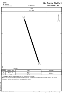
Runways:
| RWY identifier | QFU | Length (ft) | Width (ft) | Surface | LDA (ft) |
| 16 | 162° | 4000 | 75 | ASPH | |
| 34 | 342° | 4000 | 75 | ASPH |
Airport contact information
Address: Rio Grande City United States