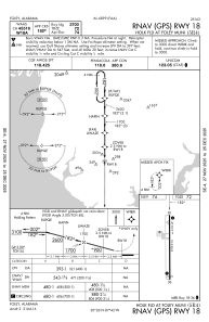
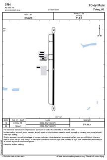


5R4 - Foley Muni
Located in Foley, United States
ICAO - 5R4, IATA -
Data provided by AirmateGeneral information
Coordinates: N30°25'40" W87°42'3"
Elevation is 74 feet MSL.
Magnetic variation is -02° East View others Airports in Alabama
Operational data
Special qualification required
Current time UTC:
Current local time:
Weather at : KJKA - Gulf Shores Intl/Jack Edwards Fld ( 16 km )
METAR: KJKA 091135Z AUTO 19007G14KT 10SM SCT033 BKN048 BKN055 27/26 A2984 RMK AO2
TAF: KJKA 091128Z 0912/1012 20010KT P6SM SCT015 BKN030 FM091600 21011KT P6SM SCT020 BKN040 FM092300 21009KT P6SM SCT020 BKN040 FM100500 21008KT P6SM BKN009 BKN015 PROB30 1007/1011 4SM TSRA BR OVC004CB
Communications frequencies: [VIEW]
Runways:
| RWY identifier | QFU | Length (ft) | Width (ft) | Surface | LDA (ft) |
| 18 | 180° | 3700 | 74 | ASPH | |
| 36 | 360° | 3700 | 74 | ASPH |
Airport contact information
Address: Foley United States
