


55T - Eagles Aerodrome
Located in Conway, United States
ICAO - 55T, IATA -
Data provided by AirmateGeneral information
Coordinates: N35°12'52" W101°24'40"
Elevation is 3475 feet MSL.
Magnetic variation is 09° East View others Airports in Texas
Operational data
Special qualification required
Current time UTC:
Current local time:
Weather at : KAMA - Rick Husband Amarillo Intl ( 27 km )
METAR: KAMA 091653Z 07019G30KT 10SM FEW060 22/M02 A3000 RMK AO2 PK WND 06030/1652 SLP116 T02221022
TAF: KAMA 091720Z 0918/1018 08017KT P6SM SKC FM100000 09016KT P6SM FEW250 FM100500 08010KT P6SM FEW250 FM101000 03007KT P6SM FEW240
Communications frequencies: [VIEW]
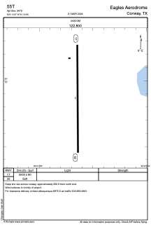
Runways:
| RWY identifier | QFU | Length (ft) | Width (ft) | Surface | LDA (ft) |
| 17 | 180° | 5000 | 80 | GRASS | |
| 35 | 0° | 5000 | 80 | GRASS |
Airport contact information
Address: Conway United States