


4M5 - Dermott Muni
Located in Dermott, United States
ICAO - 4M5, IATA -
Data provided by AirmateGeneral information
Coordinates: N33°29'17" W91°26'33"
Elevation is 135 feet MSL.
Magnetic variation is 03° East View others Airports in Arkansas
Operational data
Special qualification required
Current time UTC:
Current local time:
Weather at : KLLQ - Monticello Muni/Ellis Fld ( 33 km )
METAR: KLLQ 261653Z AUTO 19012G26KT 10SM FEW025 29/23 A2971 RMK AO2 PK WND 21027/1642 SLP056 T02890228
TAF: KLLQ 261133Z 2612/2712 18006KT P6SM BKN020 FM261500 19008KT P6SM BKN030 FM261800 20010G20KT P6SM SCT040 FM270000 22011G18KT P6SM OVC250 FM270600 23009G18KT P6SM BKN250
Communications frequencies: [VIEW]
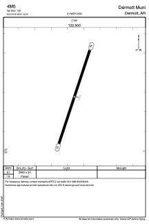
Runways:
| RWY identifier | QFU | Length (ft) | Width (ft) | Surface | LDA (ft) |
| 01 | 18° | 2980 | 50 | ASPH | |
| 19 | 198° | 2980 | 50 | ASPH |
Airport contact information
Address: Dermott United States