


4G8 - Columbia
Located in Columbia Station, United States
ICAO - 4G8, IATA -
Data provided by AirmateGeneral information
Coordinates: N41°19'7" W81°57'38"
Elevation is 810 feet MSL.
Magnetic variation is -06° East View others Airports in Ohio
Operational data
Special qualification required
Current time UTC:
Current local time:
Weather at : KCLE - Cleveland-Hopkins Intl ( 13 km )
METAR: KCLE 080651Z 21008KT 10SM BKN250 20/17 A2960 RMK AO2 SLP032 T02000167
TAF: KCLE 080529Z 0806/0912 22010KT P6SM SCT250 FM081100 25010KT P6SM SCT130 FM081700 27011KT P6SM FEW250 FM090200 01008KT P6SM SCT250 FM090500 06009KT P6SM SCT140 FM090800 07008KT P6SM VCSH BKN200
Communications frequencies: [VIEW]
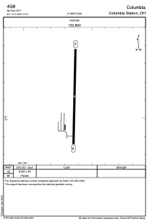
Runways:
| RWY identifier | QFU | Length (ft) | Width (ft) | Surface | LDA (ft) |
| 18 | 181° | 3152 | 40 | ASPH | |
| 36 | 1° | 3152 | 40 | ASPH |
Airport contact information
Address: Columbia Station United States