


49C - Camp Lake
Located in Camp Lake, United States
ICAO - 49C, IATA -
Data provided by AirmateGeneral information
Coordinates: N42°31'40" W88°9'22"
Elevation is 755 feet MSL.
Magnetic variation is -01° East View others Airports in Wisconsin
Operational data
Special qualification required
Current time UTC:
Current local time:
Weather at : KENW - Kenosha Rgnl ( 20 km )
METAR: KENW 171953Z 08009KT 10SM CLR 22/14 A2980 RMK AO2 SLP087 T02170144
TAF: KENW 171720Z 1718/1818 07005KT P6SM FEW040 FM180100 10005KT P6SM SKC FM181400 16007KT P6SM FEW240
Communications frequencies: [VIEW]
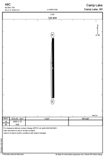
Runways:
| RWY identifier | QFU | Length (ft) | Width (ft) | Surface | LDA (ft) |
| 18 | 0° | 2260 | 75 | GRASS | |
| 36 | 0° | 2260 | 75 | GRASS |
Airport contact information
Address: Camp Lake United States