


44T - Hoskins Fld
Located in Olympia, United States
ICAO - 44T, IATA -
Data provided by AirmateGeneral information
Coordinates: N46°59'33" W122°49'40"
Elevation is 213 feet MSL.
Magnetic variation is 20° East View others Airports in Washington
Operational data
Special qualification required
Current time UTC:
Current local time:
Weather at : KOLM - Olympia Rgnl ( 6 km )
METAR: KOLM 091754Z 05010KT 10SM CLR 18/07 A3035 RMK AO2 SLP277 T01780072 10178 20028 58009
TAF: KOLM 091720Z 0918/1018 04009KT P6SM SKC FM100400 02003KT P6SM SKC
Communications frequencies: [VIEW]
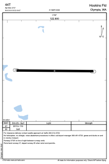
Runways:
| RWY identifier | QFU | Length (ft) | Width (ft) | Surface | LDA (ft) |
| 07 | 91° | 2015 | 116 | GRASS | |
| 25 | 271° | 2015 | 116 | GRASS |
Airport contact information
Address: Olympia United States