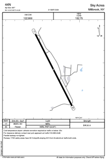


44N - Sky Acres
Located in Millbrook, United States
ICAO - 44N, IATA -
Data provided by AirmateGeneral information
Coordinates: N41°42'27" W73°44'17"
Elevation is 697 feet MSL.
Magnetic variation is -14° East View others Airports in New York
Operational data
Special qualification required
Current time UTC:
Current local time:
Weather at : KPOU - Hudson Valley Rgnl ( 15 km )
METAR: KPOU 081553Z 22006KT 10SM FEW030 SCT038 24/18 A2953 RMK AO2 SLP997 T02440183
TAF: KPOU 081413Z 0814/0912 21005KT P6SM SCT016 TEMPO 0814/0816 BKN016 FM081800 25010G17KT P6SM SCT050 FM082300 28006KT P6SM FEW080 FM091000 33008KT P6SM BKN050
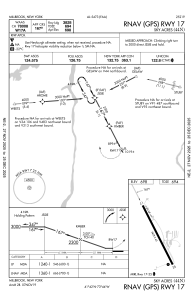
Communications frequencies: [VIEW]
Runways:
| RWY identifier | QFU | Length (ft) | Width (ft) | Surface | LDA (ft) |
| 17 | 153° | 3828 | 60 | ASPH | |
| 35 | 333° | 3828 | 60 | ASPH |
Airport contact information
Address: Millbrook United States