


43MI - West Gladstone
Located in Gladstone, United States
ICAO - 43MI, IATA -
Data provided by AirmateGeneral information
Coordinates: N45°51'39" W87°7'4"
Elevation is 729 feet MSL.
Magnetic variation is -03° East View others Airports in Michigan
Operational data
Special qualification required
Current time UTC:
Current local time:
Weather at : KESC - Delta County ( 15 km )
METAR: KESC 081156Z AUTO 31003KT 10SM BKN011 11/11 A2962 RMK AO2 RAB04E16 SLP034 P0000 60018 70104 T01110111 10111 20100 53025 $
Communications frequencies: [VIEW]
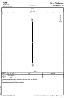
Runways:
| RWY identifier | QFU | Length (ft) | Width (ft) | Surface | LDA (ft) |
| 18 | 180° | 2977 | 68 | GRASS | |
| 36 | 360° | 2977 | 68 | GRASS |
Airport contact information
Address: Gladstone United States