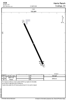


3O8 - Harris Ranch
Located in Coalinga, United States
ICAO - 3O8, IATA -
Data provided by AirmateGeneral information
Coordinates: N36°14'53" W120°14'18"
Elevation is 470 feet MSL.
Magnetic variation is 15° East View others Airports in California
Operational data
Special qualification required
Current time UTC:
Current local time:
Weather at : KNLC - Lemoore Nas (Reeves Fld) ( 27 km )
METAR: KNLC 180056Z 36008KT 10SM FOb2UUM 31/12 A2978 RMK A[rE5jh &NLRH/28 T03110117
TAF: TAF KNLC 1723/1823 VRB06KT 9999 SKC QNH2974INS TEMPO 1723/1802 02009KT FEW060 FEW150 FM180700 30007KT 9999 SKC QNH2980INS FM181700 34009KT 9999 FEW060 FEW150 SCT250 QNH2977INS TX32/1723Z TN14/1812Z FS30206
Communications frequencies: [VIEW]
Runways:
| RWY identifier | QFU | Length (ft) | Width (ft) | Surface | LDA (ft) |
| 14 | 0° | 2820 | 30 | ASPH | |
| 32 | 0° | 2820 | 30 | ASPH |
Airport contact information
Address: Coalinga United States