


3O5 - Walters Muni
Located in Walters, United States
ICAO - 3O5, IATA -
Data provided by AirmateGeneral information
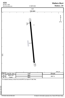
Coordinates: N34°22'21" W98°24'21"
Elevation is 1058 feet MSL.
Magnetic variation is 07° East View others Airports in Oklahoma
Operational data
Special qualification required
Current time UTC:
Current local time:
Weather at : KLAW - Lawton-Fort Sill Rgnl ( 22 km )
METAR: KLAW 091153Z AUTO 03009KT 10SM CLR 16/08 A2983 RMK AO2 SLP090 T01560078 10194 20139 53020
TAF: KLAW 091127Z 0912/1012 02008KT P6SM SCT080 FM091400 05016G26KT P6SM BKN050 FM100200 02010KT P6SM SCT100
Communications frequencies: [VIEW]
Runways:
| RWY identifier | QFU | Length (ft) | Width (ft) | Surface | LDA (ft) |
| 16 | 174° | 2900 | 50 | ASPH | |
| 34 | 354° | 2900 | 50 | ASPH |
Airport contact information
Address: Walters United States