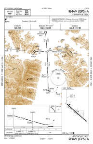
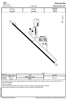


32S - Stevensville
Located in Stevensville, United States
ICAO - 32S, IATA -
Data provided by AirmateGeneral information
Coordinates: N46°31'30" W114°3'10"
Elevation is 3614 feet MSL.
Magnetic variation is 16° East View others Airports in Montana
Operational data
Special qualification required
Current time UTC:
Current local time:
Weather at : KMSO - Missoula Montana ( 44 km )
METAR: KMSO 081453Z 32006KT 10SM OVC032 06/02 A3013 RMK AO2 RAB07E12 SLP215 P0000 60000 T00560022 51019
TAF: KMSO 081120Z 0812/0912 32008KT P6SM -RA SCT030 OVC045 FM081600 31008KT 6SM -RA OVC025 FM082200 33008KT P6SM OVC035
Communications frequencies: [VIEW]
Runways:
| RWY identifier | QFU | Length (ft) | Width (ft) | Surface | LDA (ft) |
| 12 | 133° | 3809 | 75 | ASPH | |
| 30 | 313° | 3809 | 75 | ASPH |
Airport contact information
Address: Stevensville United States
