


2R1 - Le Maire Meml
Located in Jeanerette, United States
ICAO - 2R1, IATA -
Data provided by AirmateGeneral information
Coordinates: N29°53'57" W91°39'58"
Elevation is 14 feet MSL.
Magnetic variation is 04° East View others Airports in Louisiana
Operational data
Special qualification required
Current time UTC:
Current local time:
Weather at : KARA - Acadiana Rgnl ( 26 km )
METAR: KARA 091153Z 17005KT 2 1/2SM BR FEW016 BKN025 OVC032 26/24 A2976 RMK AO2 SLP076 60000 T02560244 10261 20256 53006
TAF: KARA 091148Z 0912/1012 19006KT 3SM BR BKN025 OVC035 FM091400 18007KT P6SM OVC015 FM100200 18007KT 4SM BR BKN008 FM101000 30005KT P6SM OVC007
Communications frequencies: [VIEW]
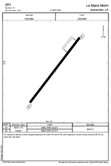
Runways:
| RWY identifier | QFU | Length (ft) | Width (ft) | Surface | LDA (ft) |
| 04 | 37° | 3000 | 75 | ASPH | |
| 22 | 217° | 3000 | 75 | ASPH |
Airport contact information
Address: Jeanerette United States