


2H5 - Houston Fort Bend
Located in Houston, United States
ICAO - 2H5, IATA -
Data provided by AirmateGeneral information
Coordinates: N29°29'57" W95°53'54"
Elevation is 105 feet MSL.
View others Airports in Texas
Operational data
Special qualification required
Current time UTC:
Current local time:
Weather at : KSGR - Sugar Land Rgnl ( 27 km )
METAR: KSGR 091553Z 15009KT 3SM HZ OVC029 30/25 A2972 RMK AO2 SLP065 T03000250
TAF: KSGR 091120Z 0912/1012 14004KT 3SM BR FEW006 BKN022 FM091700 14008KT 6SM HZ BKN025 FM092100 13008KT 6SM HZ SCT035 FM100200 VRB04KT P6SM VCTS BKN035CB FM100500 VRB04KT P6SM BKN025 FM101000 03006KT P6SM BKN010
Communications frequencies: [VIEW]
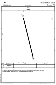
Runways:
| RWY identifier | QFU | Length (ft) | Width (ft) | Surface | LDA (ft) |
| 17 | 166° | 4400 | 100 | GRASS | |
| 35 | 346° | 4400 | 100 | GRASS |
Airport contact information
Address: Houston United States