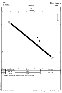


24R - Dilley Airpark
Located in Dilley, United States
ICAO - 24R, IATA -
Data provided by AirmateGeneral information
Coordinates: N28°41'8" W99°11'21"
Elevation is 542 feet MSL.
Magnetic variation is 08° East View others Airports in Texas
Operational data
Special qualification required
Current time UTC:
Current local time:
Weather at : KCOT - Cotulla-La Salle County ( 26 km )
METAR: KCOT 091353Z AUTO 11008KT 5SM HZ OVC012 28/24 A2967 RMK AO2 SLP038 T02780239
TAF: KCOT 091130Z 0912/1012 14006KT 4SM BR OVC008 FM091400 11005KT 5SM BR OVC015 FM091600 VRB06KT 6SM HZ SCT015 BKN250 FM100800 09010KT P6SM OVC015
Communications frequencies: [VIEW]
Runways:
| RWY identifier | QFU | Length (ft) | Width (ft) | Surface | LDA (ft) |
| 12 | 129° | 3400 | 60 | ASPH | |
| 30 | 309° | 3400 | 60 | ASPH |
Airport contact information
Address: Dilley United States