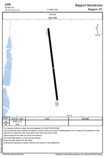


23N - Bayport Aerodrome
Located in Bayport, United States
ICAO - 23N, IATA -
Data provided by AirmateGeneral information
Coordinates: N40°45'27" W73°3'10"
Elevation is 39 feet MSL.
Magnetic variation is -13° East View others Airports in New York
Operational data
Special qualification required
Current time UTC:
Current local time:
Weather at : KISP - Long Island Mac Arthur ( 6 km )
METAR: KISP 081756Z 19010KT 10SM BKN006 OVC055 17/15 A2959 RMK AO2 SLP019 60041 T01720150 10183 20156 58015
TAF: KISP 081731Z 0818/0918 20012G19KT P6SM SCT009 SCT060 TEMPO 0818/0820 BKN009 FM082000 21012KT P6SM SCT080 FM082300 26009KT P6SM SCT080 FM090300 31008KT P6SM FEW060 FM091200 34008KT P6SM FEW035 BKN250 FM091500 01006KT P6SM SCT050 BKN080
Communications frequencies: [VIEW]
Runways:
| RWY identifier | QFU | Length (ft) | Width (ft) | Surface | LDA (ft) |
| 18 | 173° | 2753 | 75 | GRAS | |
| 36 | 353° | 2753 | 75 | GRAS |
Airport contact information
Address: Bayport United States